By using this site, you agree to the Privacy Policy and Terms of Use.
Accept
Daily LondonDaily London
Font ResizerAa
  • UK & Europe News
  • World Affairs
  • Tech & Innovation
  • Culture & Society
  • Voices of London
Reading: Severe thunderstorms sweep across south-east Queensland
Share
Font ResizerAa
Daily LondonDaily London
  • UK & Europe News
  • World Affairs
  • Tech & Innovation
  • Culture & Society
  • Voices of London
Search
  • UK & Europe News
  • World Affairs
  • Tech & Innovation
  • Culture & Society
  • Voices of London
Follow US
© 2025 Daily london. All Rights Reserved.
Daily London > World Affairs > Severe thunderstorms sweep across south-east Queensland
World Affairs

Severe thunderstorms sweep across south-east Queensland

Daily London
By Daily London
Published: November 14, 2025
Share

Daily London

A large chunk of Queensland has been told to brace for a potentially wild weekend of weather.

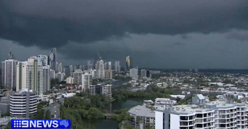
A band of severe thunderstorms swept across south-east Queensland tonight and the Bureau of Meteorology warned it was just the beginning.

Friday’s storms first struck the Darling Downs, west of Brisbane, in the afternoon and slowly tracked towards the Gold Coast.

(Nine)

“We’ve really copped it down here on the Gold Coast,” 9News Queensland weather expert Luke Bradnam said at 6pm (7pm AEDT).

“Right now it is the city and the northern suburbs seeing the fiercest part of this storm.”

The storms were tracking north-east towards the Sunshine Coast.

Some of the biggest rainfall was at Mitchelton, in Brisbane’s north, where 48 millimetres fell in just 30 minutes to 6.20pm, and at Wallumbilla, more than 400 kilometres west of Brisbane, where 41 millimetres fell at almost the same time.

The BoM said Clontarf, in Moreton Bay, copped hail up to 4 centimetres just after 6pm.

Two angry red blobs showing the most severe of the thunderstorms moving across south-east Queensland on Friday night. (Bureau of Meteorology)
The rain radar showing just how far inland the band of storms stretches in south-east Queensland. (Bureau of Meteorology)

Wind gusts of 91km/h were recorded at Nambour on the Sunshine Coast at 8.31pm.

The storms were tracking towards the ocean but still threatened big downpours and damaging conditions, the BoM said.

“Severe thunderstorms are likely to produce heavy rainfall that may lead to flash flooding and damaging winds in the warning area over the next several hours,” it said.

And the outlook for the weekend does not get much better.

The bureau has warned of scattered showers and thunderstorms across the state, with the potential for severe thunderstorms with heavy rainfall, damaging wind gusts, and large hail in south-east Queensland.

You Might Also Like

Bondi Beach shooting: Attack likened to Port Arthur massacre 11 years after Sydney siege
US Donald Trump expands trade war with new threat of 50 per cent tariff on Canadian aircraft
‘Urgent warning to all Australians about Triple Zero calls’
New poll shows Aussies support tough changes on hate speech laws
Hospitals across Sydney caring for 40 patients after Bondi Beach mass shooting
Share This Article
Facebook Twitter Whatsapp Whatsapp Email Print
Previous Article Queensland family faces fine over ‘immaculate’ lawn
Next Article Amyl and the Sniffers’ free gig shut down over security fears at Fed Square

Stay Connected

16k Like
85k Follow
45.6k Subscribe
Telegram Follow
- Advertisement -

Latest News

Interstate crews brought in to help firefighters battle massive blaze
World Affairs
International Olympic Committee grills organisers at Milan meeting
World Affairs
Search for vulnerable woman who disappeared from bus stop nearly two months ago
World Affairs
Man arrested after allegedly mimicking shooting near footbridge
World Affairs

Daily London – The Global Pulse from the UK

Sign Up for Our Newsletter

Subscribe to our newsletter to get our newest articles instantly!

[email-subscribers-form id=”1″]

Daily LondonDaily London
© 2025 Daily London. All Rights Reserved.