By using this site, you agree to the Privacy Policy and Terms of Use.
Accept
Daily LondonDaily London
Font ResizerAa
  • UK & Europe News
  • World Affairs
  • Tech & Innovation
  • Culture & Society
  • Voices of London
Reading: Tropical low forecast to reach ‘cyclone intensity’ before landfall, BOM says
Share
Font ResizerAa
Daily LondonDaily London
  • UK & Europe News
  • World Affairs
  • Tech & Innovation
  • Culture & Society
  • Voices of London
Search
  • UK & Europe News
  • World Affairs
  • Tech & Innovation
  • Culture & Society
  • Voices of London
Follow US
© 2025 Daily london. All Rights Reserved.
Daily London > World Affairs > Tropical low forecast to reach ‘cyclone intensity’ before landfall, BOM says
World Affairs

Tropical low forecast to reach ‘cyclone intensity’ before landfall, BOM says

Daily London
By Daily London
Published: January 9, 2026
Share

Daily London

A tropical low developing in the Coral Sea off northern Queensland will turn southwest later today and is forecast to reach cyclone intensity before it reaches the coast on the weekend.

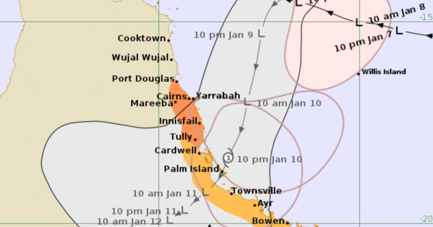
The slow-moving low, named 12U, will head towards the north tropical coast tonight and is likely to cross between Cairns and Ayr late Saturday evening or early Sunday.

Regardless of whether it reaches tropical cyclone intensity, the Bureau of Meteorology is warning the impacts of the heavy rainfall and damaging winds on the already saturated region will be the same.

The forecast track map of tropical low 12U. (Bureau of Meteorology)

The Bureau warns the underlying wet soil puts the region at increased risk of tree fall and landslides.

While the cyclone warning is in place for the area from Port Douglas to Tully, including Cairns and Innisfail, a broader severe weather warning is in place for a 1000km stretch of coastline from Hope Vale in the north to Mackay, which will be hit with potentially flooding rain, beginning north of Townsville and then moving south.

“Damaging winds will extend south along the coast throughout the warning area on Saturday, and will turn east to northeasterly south of 12U on Saturday afternoon and evening,” the Bureau said in its latest statement.

“Conditions could begin to ease about the North Tropical Coast north of Innisfail by Saturday evening, but are likely to persist into Sunday over parts of the Herbert and Lower Burdekin and Central Coast and Whitsundays.

”Rainfall totals and warning area is dependent on the development and position of the tropical low.”

Further warnings will be issued as the system moves closer to the coast and residents in warning areas are advised to stay up to date.

You Might Also Like

Man charged over random attack on teen and woman who rushed to help
Man jailed for creating ‘evil twin’ WiFi networks at Australian airports
Body found in search for man missing in NSW dam
Investigation under way after glass fire bombs thrown at Sydney home in ‘targeted’ attack
Diabetic driver in bid to dodge five-death inquest
Share This Article
Facebook Twitter Whatsapp Whatsapp Email Print
Previous Article Bondi hero meets former Prime Minister Kevin Rudd in latest engagement on US trip
Next Article US federal immigration agents shoot and injure two people in car outside hospital

Stay Connected

16k Like
85k Follow
45.6k Subscribe
Telegram Follow
- Advertisement -

Latest News

Interstate crews brought in to help firefighters battle massive blaze
World Affairs
International Olympic Committee grills organisers at Milan meeting
World Affairs
Search for vulnerable woman who disappeared from bus stop nearly two months ago
World Affairs
Man arrested after allegedly mimicking shooting near footbridge
World Affairs

Daily London – The Global Pulse from the UK

Sign Up for Our Newsletter

Subscribe to our newsletter to get our newest articles instantly!

[email-subscribers-form id=”1″]

Daily LondonDaily London
© 2025 Daily London. All Rights Reserved.