
Daily London
Despite its tiny population, Greenland has become the focal point of tensions between the United States and Europe.
A territory of Denmark, US President Donald Trump is seeking to annex the island to become part of the United States.
Greenland has substantial strategic value because of its location, as well as a plethora of rare earths which have been, up to this point, very difficult to access.
So why does it look different on a map?
The answer comes down to a simple geometric challenge – it is impossible to accurately project a curved 3D object on a flat surface.
“Imagine you managed to take your peel off the orange only ripping at one place,” she said.
“If you tried to flatten it, what would happen? You’d get more rips in it near the edge.”
On a world map with the North Pole up top and the South Pole at the bottom, the distortions also happen at the edge.
The further north and further south you are on a flat map, the more stretched out it appears.
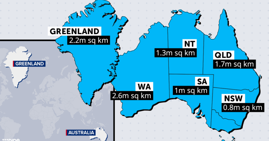
The Democratic Republic of Congo, which is situated right on the equator, is bigger than Greenland, though it doesn’t appear that way on the map.
The classic culprit is a map called the Mercator Projection, designed by Gerardus Mercator in 1569.
“It was actually a really revolutionary projection for its time,” Griffin said.
In the days before GPS, navigators could draw a line on a Mercator Projection map and get from point A to point B with just a compass bearing.
“It wouldn’t be the shortest way of getting there. It would be a fairly significant detour, but you’d be sure that you’d get there,” Griffin said.
“When faced with the choice of taking longer or being lost in the middle of the ocean – which one would you pick?”
Though at the time it was first drawn, Mercator did not know about Australia and instead drew a large blob where it was assumed another continent was.
By contrast, the Robinson Projection devised in 1963 stretches the world map less for a more accurate look at the world.