
Daily London
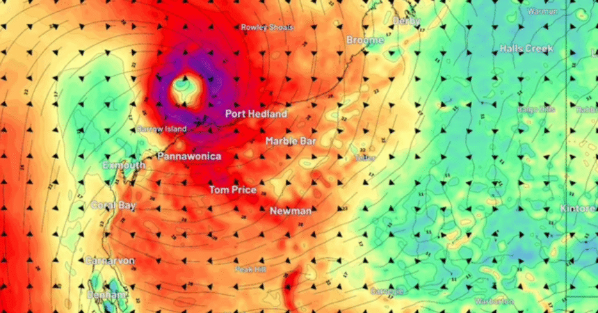
A low-pressure system currently sits over the Northern Territory, where it’s bringing heavy rain totals.
“The low is unlikely to become a tropical cyclone while it remains over land,” Weatherzone’s Ben Domensino wrote.
“However, forecast models indicate the system should move towards the west in the coming days and move off Western Australia’s Kimberley coast later this week, most likely around Friday.”
Over the warmer ocean waters off the northern WA coast, the system’s likelihood of intensifying increases.
The Bureau of Meteorology currently rates the tropical low – named system 21U – a “moderate” 25 per cent chance of reaching cyclone status between the coming Saturday and next Monday.
However, Weatherzone said other modelling, including from the European Centre for Medium-Range Weather Forecasts, rated the change of a cyclone in the same time frame much higher, at 60 to 70 per cent.
The Bureau’s forecasts can change rapidly depending on storm activity throughout the day.
Whatever the system’s status, it is likely to continue to bring heavy rain and flooding for the rest of the week across the northern pars of the NT and WA.
“Moisture associated with the low will also fuel daily rain and thunderstorm activity over large areas of northern and eastern Australia this week,” Domensino wrote.
Multiple weather warnings have been issued, including flood warnings and a severe weather warning for rain in the NT.
One of the flood watch warnings is for the Tanami Desert, illustrating the range of the system’s influence.
Early flood warnings have also been issued for the Kimberleys in WA, while multiple flood warnings in various states are in place across Queensland.
NEVER MISS A STORY: Get your breaking news and exclusive stories first by following us across all platforms.