By using this site, you agree to the Privacy Policy and Terms of Use.
Accept
Daily LondonDaily London
Font ResizerAa
  • UK & Europe News
  • World Affairs
  • Tech & Innovation
  • Culture & Society
  • Voices of London
Reading: Western Australia’s Kimberley coast braces for category four weather system
Share
Font ResizerAa
Daily LondonDaily London
  • UK & Europe News
  • World Affairs
  • Tech & Innovation
  • Culture & Society
  • Voices of London
Search
  • UK & Europe News
  • World Affairs
  • Tech & Innovation
  • Culture & Society
  • Voices of London
Follow US
© 2025 Daily london. All Rights Reserved.
Daily London > World Affairs > Western Australia’s Kimberley coast braces for category four weather system
World Affairs

Western Australia’s Kimberley coast braces for category four weather system

Daily London
By Daily London
Published: December 29, 2025
Share

Daily London

Severe tropical Cyclone Hayley is making its way towards the north-west of Western Australia‘s Kimberley coast, bringing with it destructive winds and heavy rain which threaten to trigger flash flooding.
The category four system is moving south-east towards the coast, and is likely to reach the northern part of the Dampier Peninsula this evening, according to the Bureau of Meteorology’s latest cyclone track map.

“Hayley is likely at its peak strength, and is forecast to start weakening today prior to landfall,” the bureau said.

Severe tropical Cyclone Haley is making its way towards the northwest of Western Australia’s Kimberley coast. (BoM)

“However, it is still forecast at category three strength prior to landfall.”

The system is currently 240 kilometres west of Cape Leveque and 255 kilometres north-west of Broome, with sustained winds near the centre of 165km/h and wind gusts of to 230km/h.

The current warning zone includes the area north of Broome to Kuri Bay, including Dampier Peninsula and Derby.

The bureau said destructive wind gusts of to 170 km/h could possibly strike the northern Dampier Peninsula, including Beagle Bay and Cape Leveque, from early this afternoon.

Those destructive winds could extend east to Cockatoo Island later this evening or early tomorrow.

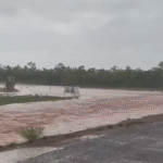
Heavy rainfall which may lead to flash flooding is possible near the track for the area under the warning from today.

Tides are expected to be higher than normal as the cyclone approaches the west Kimberley Coast.

You Might Also Like

NSW woman Naomi opened a letter and discovered a secret $6400 energy debt
Billions of dollars of debt wiped from accounts of 100,000 Aussies
Suspected drunk driver cracks open vodka can after car ploughs into family home
Federal government to separate hate speech bill after Greens pull support
Venezuelan opposition leader Maria Corino Machado presents Donald Trump with Nobel Peace Prize at White House meeting
Share This Article
Facebook Twitter Whatsapp Whatsapp Email Print
Previous Article Three including teen boy injured in NSW dog attack
Next Article Life-threatening flash floods set for state’s north; Cairns, Townsville brace for heavy falls

Stay Connected

16k Like
85k Follow
45.6k Subscribe
Telegram Follow
- Advertisement -

Latest News

Interstate crews brought in to help firefighters battle massive blaze
World Affairs
International Olympic Committee grills organisers at Milan meeting
World Affairs
Search for vulnerable woman who disappeared from bus stop nearly two months ago
World Affairs
Man arrested after allegedly mimicking shooting near footbridge
World Affairs

Daily London – The Global Pulse from the UK

Sign Up for Our Newsletter

Subscribe to our newsletter to get our newest articles instantly!

[email-subscribers-form id=”1″]

Daily LondonDaily London
© 2025 Daily London. All Rights Reserved.